
Súbor:Abbasid Caliphate 891-892.png

Veľkosť tohto náhľadu: 800 × 382 pixelov. Iné rozlíšenia: 320 × 153 pixelov | 640 × 306 pixelov | 1 024 × 490 pixelov | 1 280 × 612 pixelov | 3 054 × 1 460 pixelov .
Pôvodný súbor (3 054 × 1 460 pixelov, veľkosť súboru: 1,44 MB, MIME typ: image/png)
Zhrnutie
| Popis |
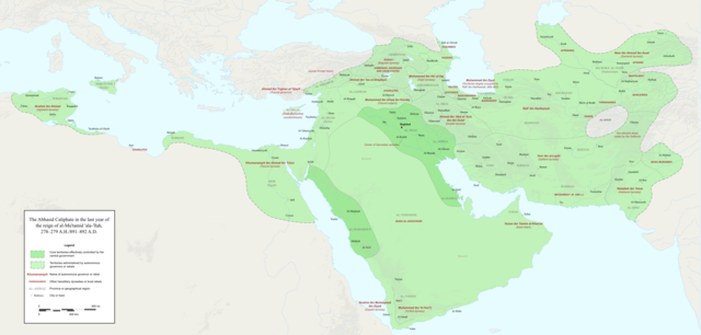
English: Map of the Abbasid Caliphate at the end of the reign of al-Mu'tamid in 891-892. Dark green denotes provinces under the effective control of the central government; light green denotes provinces under the control of autonomous governors or rebels.
The core Abbasid territories include Shahrazur, Darabadh, al-Samaghan, Hulwan, Masabadhan, Mihrijanqadhaq, the Euphrates districts, and Qarqisiyya (al-Tabari v. 37, p. 98; Bianquis p. 96). Map originally created as an .SVG file in Inkscape and converted to .PNG for size reasons. Background topography taken from DEMIS Mapserver, which are public domain. Works Cited:
|
| Dátum | |
| Zdroj | Vlastné dielo |
| Autor | Ro4444 |
| Ďalšie verzie |
 |
Licencovanie
Ja, držiteľ autorských práv k tomuto dielu ho týmto zverejňujem za podmienok nasledovnej licencie:
Tento soubor podléhá licenci Creative Commons Uveďte autora-Zachovejte licenci 4.0 International
- Môžete slobodne:
- zdieľať – kopírovať, šíriť a prenášať dielo
- meniť ho – upravovať dielo
- Za nasledovných podmienok:
- uvedenie autorov – Musíte spomenúť autorov (jednotlivo alebo kolektívne), poskytnúť odkaz na licenciu a uviesť, či ste niečo zmenili. Môžete to urobiť ľubovoľným primeraným spôsobom, ale nie spôsobom naznačujúcim, že poskytovateľ licencie podporuje vás alebo vaše použitie diela.
- meniť za rovnakých podmienok – Ak toto dielo zmeníte, prevediete do inej formy alebo použijete ako základ iného diela, musíte výsledok šíriť pod rovnakou alebo kompatibilnou licenciou ako originál.
História súboru
Po kliknutí na dátum/čas uvidíte ako súbor vyzeral vtedy.
| Dátum/Čas | Náhľad | Rozmery | Používateľ | Komentár | |
|---|---|---|---|---|---|
| aktuálna | 23:18, 3. december 2017 | | 3 054 × 1 460 (1,44 MB) | Ro4444 | Further color corrections |
| 22:50, 3. december 2017 |  | 3 054 × 1 460 (1,44 MB) | Ro4444 | Color correction | |
| 21:11, 3. december 2017 |  | 3 054 × 1 460 (1,44 MB) | Ro4444 | User created page with UploadWizard |
Použitie súboru
Žiadne stránky neobsahujú odkazy na tento súbor.
Globálne využitie súborov
Nasledovné ďalšie wiki používajú tento súbor:
- Použitie na ar.wikipedia.org
- Použitie na de.wikiversity.org
- Použitie na en.wikipedia.org
- Použitie na en.wikibooks.org
- Použitie na et.wikipedia.org
- Použitie na fa.wikipedia.org
- Použitie na hy.wikipedia.org
- Použitie na id.wikipedia.org
- Použitie na ja.wikipedia.org
- Použitie na no.wikipedia.org
- Použitie na pt.wikipedia.org
- Použitie na sco.wikipedia.org
- Použitie na uk.wikipedia.org
- Použitie na uz.wikipedia.org
- Použitie na zh.wikipedia.org