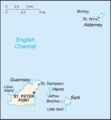
Súbor:Guernsey sm02.png
Vzhľad
Guernsey_sm02.png (325 × 350 pixelov, veľkosť súboru: 4 KB, MIME typ: image/png)
História súboru
Po kliknutí na dátum/čas uvidíte ako súbor vyzeral vtedy.
| Dátum/Čas | Náhľad | Rozmery | Používateľ | Komentár | |
|---|---|---|---|---|---|
| aktuálna | 19:42, 29. júl 2012 |  | 325 × 350 (4 KB) | Ras67 | cropped, opt. |
| 23:20, 7. máj 2005 |  | 329 × 355 (9 KB) | Voyager | ||
| 23:17, 7. máj 2005 |  | 329 × 355 (9 KB) | Voyager | Bailiwick of Guernsey Converted to png format. Original from http://www.lib.utexas.edu/maps/cia02/guernsey_sm02.gif (PCL public domain map collection) {{PD}} Category:Maps of the United Kingdom |
Použitie súboru
Na tento súbor odkazujú nasledujúce 4 stránky:
Globálne využitie súborov
Nasledovné ďalšie wiki používajú tento súbor:
- Použitie na af.wikipedia.org
- Použitie na av.wikipedia.org
- Použitie na ba.wikipedia.org
- Použitie na be-tarask.wikipedia.org
- Použitie na be.wikipedia.org
- Použitie na ca.wikipedia.org
- Použitie na cs.wikipedia.org
- Použitie na da.wikipedia.org
- Použitie na de.wikipedia.org
- Použitie na en.wikipedia.org
- Použitie na eo.wikipedia.org
- Použitie na es.wikipedia.org
- Použitie na fa.wikipedia.org
- Použitie na fi.wikipedia.org
- Použitie na fr.wikipedia.org
- Použitie na fy.wikipedia.org
- Použitie na gag.wikipedia.org
- Použitie na gd.wikipedia.org
- Použitie na gl.wikipedia.org
- Použitie na id.wikipedia.org
- Použitie na io.wikipedia.org
- Použitie na is.wikipedia.org
- Použitie na it.wikipedia.org
- Použitie na it.wikinews.org
- Použitie na ja.wikipedia.org
Zobraziť ďalšie globálne použitie tohto súboru.


