
Súbor:Karte antarktis2.png

Veľkosť tohto náhľadu: 783 × 600 pixelov. Iné rozlíšenia: 313 × 240 pixelov | 627 × 480 pixelov | 1 003 × 768 pixelov | 1 300 × 996 pixelov .
Pôvodný súbor (1 300 × 996 pixelov, veľkosť súboru: 259 KB, MIME typ: image/png)
|
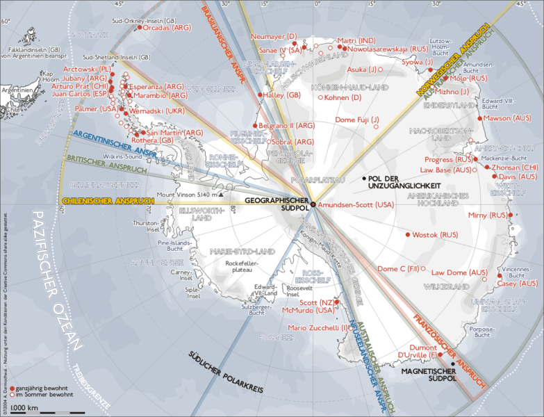
- Darstellung zeigt die Antarktis, die Geographie, Forschungsstationen und die Gebietsansprüche einzelner Länder.
- Zeichnung erstellt 2004 von Sansculotte. Bild ist unter der GNU FDL zur weiteren Verwendung freigegeben.
- Quellenangabe und Beleg an sansculotte@despammed.com erbeten.
Source: German Wikipedia, original upload see file history

|
Bolo udelené povolenie kopírovať, širiť a/alebo meniť tento dokument za podmienok GNU Free Documentation License, verzie 1.2 alebo ktorejkoľvek neskoršej verzie publikovanej Free Software Foundation; bez Nemenných častí, bez Textov na prednej obálke a bez Textov na zadnej obálke. Kópia tejto licencie je zahrnutá v časti nazvanej GNU Free Documentation License. |
| Tento súbor podlieha licencii Creative Commons Attribution-Share Alike 3.0 Unported | ||
| ||
| Táto šablóna licencie bola pridaná k tomuto súboru počas aktualizácie licencovania GFDL. |
Tento súbor je licencovaný za podmienok Creative Commons Attribution-Share Alike 2.0 Germany.
- Môžete slobodne:
- zdieľať – kopírovať, šíriť a prenášať dielo
- meniť ho – upravovať dielo
- Za nasledovných podmienok:
- uvedenie autorov – Musíte spomenúť autorov (jednotlivo alebo kolektívne), poskytnúť odkaz na licenciu a uviesť, či ste niečo zmenili. Môžete to urobiť ľubovoľným primeraným spôsobom, ale nie spôsobom naznačujúcim, že poskytovateľ licencie podporuje vás alebo vaše použitie diela.
- meniť za rovnakých podmienok – Ak toto dielo zmeníte, prevediete do inej formy alebo použijete ako základ iného diela, musíte výsledok šíriť pod rovnakou alebo kompatibilnou licenciou ako originál.

File history German Wikipedia
(Löschen) (Aktuell) 13:33, 21. Jan 2005 . . Mr. Anderson (265090 Byte) (verlustfrei komprimiert, keine Zusatz-Chunks entfernt)
(Löschen) (Zurücksetzen) 01:14, 11. Sep 2004 . . Sansculotte (357418 Byte) (upd)
(Löschen) (Zurücksetzen) 00:55, 11. Sep 2004 . . Sansculotte (354978 Byte) (upd)
(Löschen) (Zurücksetzen) 19:11, 31. Aug 2004 . . Sansculotte (335025 Byte)
(Löschen) (Zurücksetzen) 02:00, 14. Jul 2004 . . Sansculotte (335329 Byte)
(Löschen) (Zurücksetzen) 20:41, 13. Jul 2004 . . Sansculotte (335965 Byte)
(Löschen) (Zurücksetzen) 20:13, 13. Jul 2004 . . Sansculotte (335965 Byte) (korr)
(Löschen) (Zurücksetzen) 01:44, 12. Jul 2004 . . Sansculotte (328157 Byte)
(Löschen) (Zurücksetzen) 01:26, 12. Jul 2004 . . Sansculotte (240007 Byte)
(Löschen) (Zurücksetzen) 23:03, 7. Jul 2004 . . Sansculotte (234001 Byte)
(Löschen) (Zurücksetzen) 22:11, 7. Jul 2004 . . Sansculotte (231842 Byte) (kl. korr)
(Löschen) (Zurücksetzen) 03:45, 7. Jul 2004 . . Sansculotte (224965 Byte) (kleinigkeiten korrigiert)
(Löschen) (Zurücksetzen) 02:44, 7. Jul 2004 . . Sansculotte (222783 Byte) (eigene Darstellung, Nutzung gestattet unter der GNU/FDL und der cc-by-sa)\
História súboru
Po kliknutí na dátum/čas uvidíte ako súbor vyzeral vtedy.
| Dátum/Čas | Náhľad | Rozmery | Používateľ | Komentár | |
|---|---|---|---|---|---|
| aktuálna | 10:14, 17. september 2005 | | 1 300 × 996 (259 KB) | Saperaud~commonswiki | *Darstellung zeigt die Antarktis, die Geographie, Forschungsstationen und die Gebietsansprüche einzelner Länder. *Zeichnung erstellt 2004 von Benutzer:Sansculotte. Bild ist unter der GNU FDL zur weiteren Verwendung freigegeben. *'''Quellenangabe |
Použitie súboru
Na tento súbor odkazuje nasledujúca stránka:
Globálne využitie súborov
Nasledovné ďalšie wiki používajú tento súbor:
- Použitie na af.wikipedia.org
- Použitie na ar.wikipedia.org
- Použitie na ca.wikipedia.org
- Použitie na de.wikipedia.org
- 23. Juni
- Antarktika
- Antarktis-Vertrag
- Wikipedia:Kandidaten für exzellente Bilder/Archiv2004/1
- Forschungsstationen in der Antarktis
- Portal:Antarktis
- Benutzer Diskussion:Begw/Keller (Kiste 1, 2005)
- EPICA
- Portal:Recht/Lesenswerte Artikel
- Prinzessin-Elisabeth-Station
- Portal:Antarktis/Verzeichnis
- Wikipedia:WikiProjekt Völkerrecht/Lesenswerte Artikel
- Wikipedia:Kandidaten für exzellente Bilder/Archiv2009/17
- Benutzer:KaterBegemot/Kartografen
- Wikipedia:Kartenwerkstatt/Archiv/Zurückgewiesene und zurückgestellte Aufträge 2009
- Použitie na de.wikinews.org
- Použitie na eo.wikipedia.org
- Použitie na es.wikipedia.org
- Použitie na fr.wikipedia.org
- Použitie na it.wikipedia.org
- Použitie na ja.wikipedia.org
- Použitie na no.wikipedia.org
- Použitie na pl.wikipedia.org
- Použitie na sq.wikipedia.org
- Použitie na szl.wikipedia.org
- Použitie na vi.wikipedia.org
- Použitie na www.wikidata.org