
Súbor:MapofEmergingUSMegaregions.png
Veľkosť tohto náhľadu: 800 × 533 pixelov. Iné rozlíšenia: 320 × 213 pixelov | 640 × 426 pixelov | 1 024 × 682 pixelov | 1 280 × 853 pixelov | 2 494 × 1 662 pixelov .
Pôvodný súbor (2 494 × 1 662 pixelov, veľkosť súboru: 1,55 MB, MIME typ: image/png)

|
Tento obrázek (skupina map) by měl být vytvořen pomocí vektorové grafiky jako SVG soubor. To má několik výhod; podrobnosti najdete na stránce Commons:Media for cleanup. Je-li SVG verze tohoto obrázku již k dispozici, prosím nahrajte ji. Po nahrání nahraďte tuto šablonu šablonou {{Vector version available|jméno nového obrázku.svg}}.
|
| Popis |
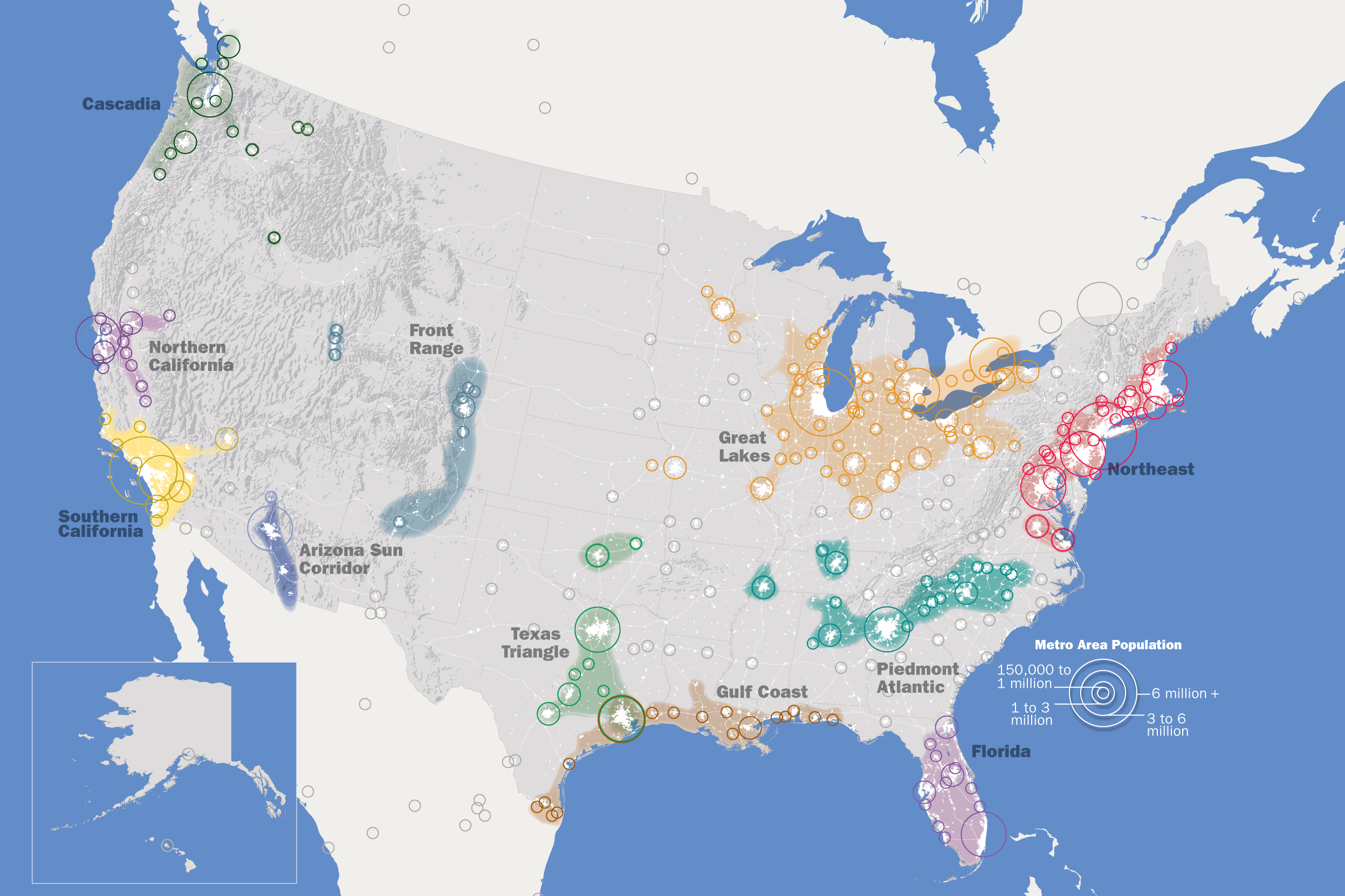
English: This map, created by the Regional Plan Association, illustrates eleven metropolitan areas that are growing into megaregions. |
| Dátum | |
| Zdroj | Vlastné dielo, https://web.archive.org/web/20130325033001/http://www.rpa.org/america2050/sync/elements/america2050map.png |
| Autor | IrvingPlNYC |
| Povolenie (Využívanie tohto súboru) |
Ja, držiteľ autorských práv k tomuto dielu ho týmto zverejňujem za podmienok nasledovnej licencie: Tento súbor podlieha licencii Creative Commons Attribution-Share Alike 3.0 Unported
|
| Ďalšie verzie |
Derivative works of this file: |
| Annotations | This image is annotated: View the annotations at Commons |
História súboru
Po kliknutí na dátum/čas uvidíte ako súbor vyzeral vtedy.
| Dátum/Čas | Náhľad | Rozmery | Používateľ | Komentár | |
|---|---|---|---|---|---|
| aktuálna | 22:14, 6. september 2019 | | 2 494 × 1 662 (1,55 MB) | Concord19 | Map size and resolution improved. Title removed as redundant, and to present a cleaner look for the encyclopedia. |
| 00:36, 23. máj 2018 |  | 1 200 × 800 (653 KB) | Howpper | Updated; metro reached 150k | |
| 06:28, 7. marec 2017 |  | 1 200 × 800 (726 KB) | Howpper | Slight correction. | |
| 15:51, 3. september 2010 |  | 1 200 × 800 (610 KB) | Tryphon | Removed watermark. | |
| 14:05, 8. september 2009 |  | 1 200 × 800 (650 KB) | IrvingPlNYC | {{Information |Description={{en|1=This map, created by the Regional Plan Association, illustrates eleven metropolitan areas that are growing into megaregions.}} |Source=Own work by uploader |Author=IrvingPlNYC |Date= |Permission= |oth |
Použitie súboru
Žiadne stránky neobsahujú odkazy na tento súbor.
Globálne využitie súborov
Nasledovné ďalšie wiki používajú tento súbor:
- Použitie na ast.wikipedia.org
- Použitie na da.wikipedia.org
- Použitie na de.wikipedia.org
- Použitie na en.wikipedia.org
- Rust Belt
- California megapolitan areas
- Southern Rocky Mountain Front
- Northeast megalopolis
- Great Lakes megalopolis
- Piedmont Atlantic megaregion
- Megaregions of the United States
- Talk:Great Lakes megalopolis
- Talk:Great Lakes Megalopolis/Archive 1
- Arizona Sun Corridor
- Inland Empire
- User:Jhenderson777/ megaregion
- Module:Location map/data/megaregion of United States
- Module:Location map/data/megaregion of United States/doc
- Wikipedia:Graphics Lab/Map workshop/Archive/Aug 2020
- User talk:Jackmcbarn/Archive 19
- Použitie na es.wikipedia.org
- Použitie na et.wikipedia.org
- Použitie na eu.wikipedia.org
- Použitie na fa.wikipedia.org
- Použitie na fr.wikipedia.org
- Použitie na he.wikipedia.org
- Použitie na id.wikipedia.org
- Použitie na it.wikipedia.org
- Použitie na ja.wikipedia.org
- Použitie na nl.wiktionary.org
- Použitie na pt.wikipedia.org
- Použitie na ro.wikipedia.org
- Použitie na ru.wikipedia.org
- Použitie na si.wikipedia.org
- Použitie na sl.wikipedia.org
- Použitie na uk.wikipedia.org
- Použitie na uz.wikipedia.org
- Použitie na xmf.wikipedia.org
- Použitie na zh.wikipedia.org