
Súbor:South Africa 2011 White population proportion map.svg

Veľkosť tohoto PNG náhľadu tohoto SVG súboru: 684 × 599 pixelov. Iné rozlíšenia: 274 × 240 pixelov | 548 × 480 pixelov | 876 × 768 pixelov | 1 168 × 1 024 pixelov | 2 337 × 2 048 pixelov | 809 × 709 pixelov .
Pôvodný súbor (SVG súbor, 809 × 709 pixelov, veľkosť súboru: 720 KB)
Zhrnutie
| Popis |
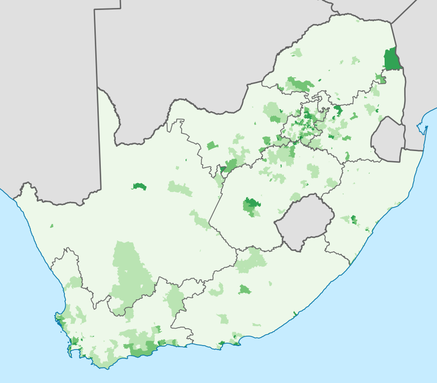
English: Map showing the proportion of the South African population that self-described as "White" in the 2011 census, at electoral ward level.
0–20%
20–40%
40–60%
60–80%
80–100%
Projection is Albers Equal-Area Conic, with standard parallels at 25.5° S and 31.5° S, and origin at 28.5° S 25.5° E. |
| Dátum | |
| Zdroj | Statistics South Africa's Census 2011 is the source of the basic population data. The map results from my own processing of the data. For ward boundaries see File:South Africa electoral wards 2011 blank.svg. |
| Autor | Htonl |
Licencovanie
The following license applies to the population data on which the map is based:

|
Držiteľ autorských práv tohto súboru, Stats SA, umožňuje komukoľvek používať ho na akýkoľvek účel, za predpokladu, že bude správne označený držiteľ autorských práv. Redistribúcia, tvorba odvodených diel, komerčné využitie a všetky ďalšie použitia sú povolené. |
Uvedenie autora:
"the user acknowledges Stats SA as the source of the basic data wherever they process, apply, utilise, publish or distribute the data, and also that they specify that the relevant application and analysis (where applicable) result from their own processing of the data" [1]
|
The following tag applies to the map itself:
| Ja, držiteľ autorských práv k tomuto dielu, uvoľňujem toto dielo ako voľné dielo (public domain). Toto platí celosvetovo. V niektorých krajinách to zákon neumožňuje; v tom prípade: Udeľujem komukoľvek právo používať toto dielo na ľubovoľné účely, bez akýchkoľvek podmienok ak také podmienky nevyžaduje zákon. |
História súboru
Po kliknutí na dátum/čas uvidíte ako súbor vyzeral vtedy.
| Dátum/Čas | Náhľad | Rozmery | Používateľ | Komentár | |
|---|---|---|---|---|---|
| aktuálna | 22:08, 16. apríl 2013 | | 809 × 709 (720 KB) | Htonl | == {{int:filedesc}} == {{Information |Description={{en|1=Map showing the proportion of the South African population that self-described as "White" in the 2011 census, at electoral ward level. {{legend|#EDF8E9|0–20%}} {{legend|#BAE4B3|20–40%}} {{leg... |
Použitie súboru
Na tento súbor odkazuje nasledujúca stránka:
Globálne využitie súborov
Nasledovné ďalšie wiki používajú tento súbor:
- Použitie na af.wikipedia.org
- Použitie na ca.wikipedia.org
- Použitie na cs.wikipedia.org
- Použitie na de.wikipedia.org
- Použitie na en.wikipedia.org
- Použitie na eu.wikipedia.org
- Použitie na fr.wikipedia.org
- Použitie na it.wikipedia.org
- Použitie na ja.wikipedia.org
- Použitie na pl.wikipedia.org
- Použitie na pt.wikipedia.org
- Použitie na ro.wikipedia.org
- Použitie na ru.wikipedia.org
- Použitie na uk.wikipedia.org
- Použitie na zh.wikipedia.org