
Súbor:Toronto map.png

Veľkosť tohto náhľadu: 800 × 595 pixelov. Iné rozlíšenia: 320 × 238 pixelov | 640 × 476 pixelov | 1 024 × 761 pixelov | 1 280 × 951 pixelov | 1 500 × 1 115 pixelov .
Pôvodný súbor (1 500 × 1 115 pixelov, veľkosť súboru: 703 KB, MIME typ: image/png)
|
| Popis |
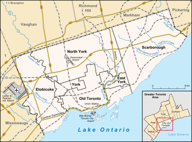
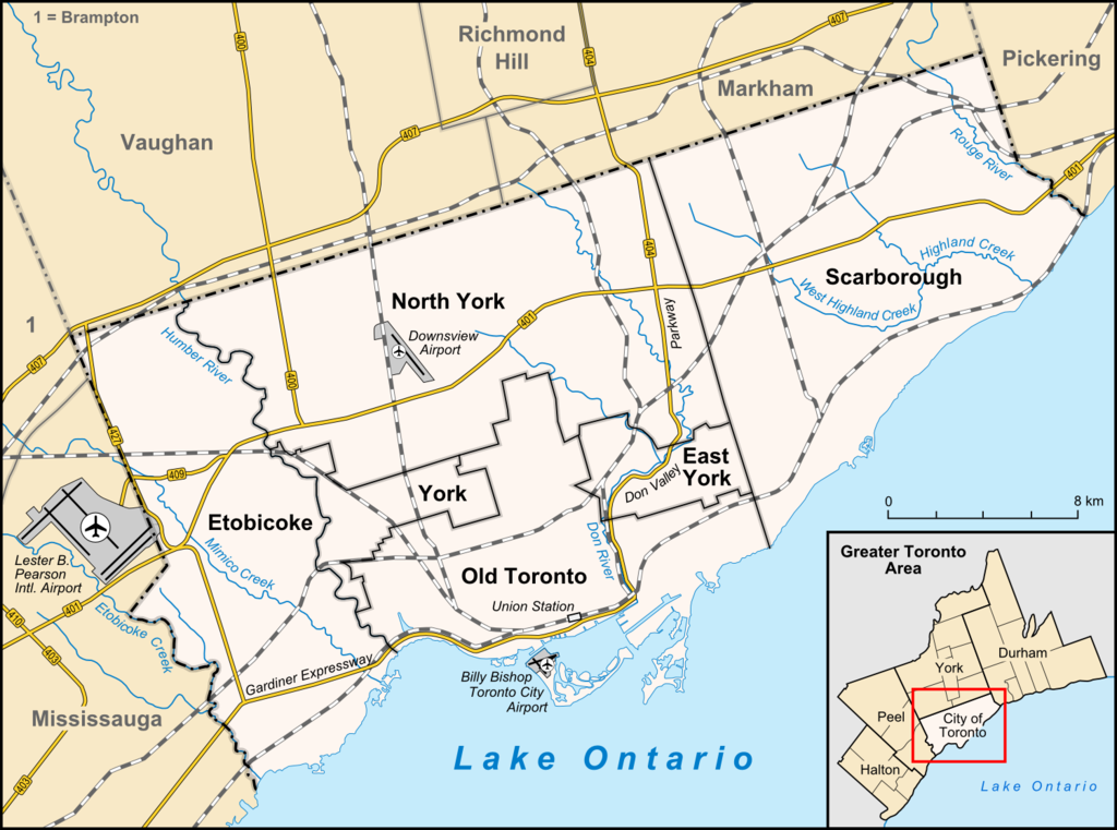
English: Map of Toronto
Français : Carte de Toronto
Deutsch: Karte von Toronto
Bahasa Indonesia: Peta kota Toronto |
| Dátum | |
| Zdroj |
own work, used:
|
| Autor | Lencer |

|
Tato mapa byla vytvořena nebo vylepšena v německé Kartenwerkstatt (Mapová laboratoř). Můžete také navrhnout mapy k vylepšení.
|
Tento súbor podlieha licencii Creative Commons Attribution-Share Alike 3.0 Unported
- Môžete slobodne:
- zdieľať – kopírovať, šíriť a prenášať dielo
- meniť ho – upravovať dielo
- Za nasledovných podmienok:
- uvedenie autorov – Musíte spomenúť autorov (jednotlivo alebo kolektívne), poskytnúť odkaz na licenciu a uviesť, či ste niečo zmenili. Môžete to urobiť ľubovoľným primeraným spôsobom, ale nie spôsobom naznačujúcim, že poskytovateľ licencie podporuje vás alebo vaše použitie diela.
- meniť za rovnakých podmienok – Ak toto dielo zmeníte, prevediete do inej formy alebo použijete ako základ iného diela, musíte výsledok šíriť pod rovnakou alebo kompatibilnou licenciou ako originál.
História súboru
Po kliknutí na dátum/čas uvidíte ako súbor vyzeral vtedy.
| Dátum/Čas | Náhľad | Rozmery | Používateľ | Komentár | |
|---|---|---|---|---|---|
| aktuálna | 14:33, 3. apríl 2012 | | 1 500 × 1 115 (703 KB) | Lencer | + don river, minor adds of river names |
| 15:59, 29. jún 2009 |  | 1 500 × 1 115 (585 KB) | SimonP | correct minor error | |
| 15:18, 29. jún 2009 |  | 1 500 × 1 115 (585 KB) | SimonP | Corect East York border | |
| 10:56, 18. jún 2009 |  | 1 500 × 1 115 (677 KB) | Lencer | + don valley parkway | |
| 18:56, 25. marec 2009 |  | 1 500 × 1 115 (673 KB) | Lencer | Int. => Intl. | |
| 12:19, 18. marec 2009 |  | 1 500 × 1 115 (672 KB) | Lencer | Vaugahn -> Vaughan | |
| 06:54, 10. marec 2009 |  | 1 500 × 1 115 (673 KB) | Lencer | fix Greater Toronto Area | |
| 12:29, 9. marec 2009 |  | 1 500 × 1 115 (672 KB) | Lencer | + Minimap, some fixes | |
| 19:10, 8. marec 2009 |  | 1 500 × 1 116 (628 KB) | Lencer | weitere Kartenelemente erg., Farben geändert | |
| 20:02, 2. marec 2009 |  | 1 500 × 1 116 (475 KB) | Lencer | Fehlerhafte Grenze bei York |
Použitie súboru
Žiadne stránky neobsahujú odkazy na tento súbor.
Globálne využitie súborov
Nasledovné ďalšie wiki používajú tento súbor:
- Použitie na ar.wikipedia.org
- Použitie na ban.wikipedia.org
- Použitie na ceb.wikipedia.org
- Použitie na ckb.wikipedia.org
- Použitie na de.wikipedia.org
- Toronto
- Benutzer:Lencer
- Wikipedia:Exzellente Bilder/Karten und Satellitenbilder
- Liste der Ortsteile von Toronto
- Wikipedia:Kartenwerkstatt/Archiv/2009-03
- Wikipedia:Kandidaten für exzellente Bilder/Archiv2009/6
- Datei:Toronto map.png
- Toronto Fire Services
- Taber Hill
- Wikipedia:Kartenwerkstatt/Schaufenster
- Wikipedia:Exzellente Bilder/Kleine Bilder
- Použitie na en.wikipedia.org
- Toronto
- Rogers Centre
- Yonge–Dundas Square
- Billy Bishop Toronto City Airport
- Don River (Ontario)
- Forest Hill, Toronto
- Humber River (Ontario)
- The Annex
- Royal Ontario Museum
- Cabbagetown, Toronto
- Rosedale, Toronto
- The Beaches, Toronto
- High Park
- The Kingsway, Toronto
- Baby Point
- Bendale
- Yonge–Eglinton
- The Junction
- Little Italy, Toronto
- New Toronto
- Leslieville
- Kensington Market
- Scotiabank Arena
- Riverdale, Toronto
- Metropolitan Toronto
- Union Station (Toronto)
- Swansea, Toronto
- Parkdale, Toronto
- Rouge River (Ontario)
- Ontario Science Centre
- The Village at Black Creek
Zobraziť ďalšie globálne použitie tohto súboru.