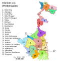
Súbor:WestBengalDistricts numbered.svg
Vzhľad

Veľkosť tohoto PNG náhľadu tohoto SVG súboru: 397 × 599 pixelov. Iné rozlíšenia: 159 × 240 pixelov | 318 × 480 pixelov | 509 × 768 pixelov | 678 × 1 024 pixelov | 1 357 × 2 048 pixelov | 768 × 1 159 pixelov .
Pôvodný súbor (SVG súbor, 768 × 1 159 pixelov, veľkosť súboru: 311 KB)
História súboru
Po kliknutí na dátum/čas uvidíte ako súbor vyzeral vtedy.
| Dátum/Čas | Náhľad | Rozmery | Používateľ | Komentár | |
|---|---|---|---|---|---|
| aktuálna | 21:04, 25. apríl 2020 |  | 768 × 1 159 (311 KB) | Debjitpaul10 | Updated text |
| 20:45, 25. apríl 2020 |  | 768 × 1 159 (113 KB) | Debjitpaul10 | Uploaded a corrected and transparent version. | |
| 06:15, 5. november 2017 |  | 576 × 601 (144 KB) | Mouryan | {{Information |Description={{en|Original summary by creator of base svg file deeptrivia. Districts of West Bengal Based on http://web.archive.org/web/20040606103522/www.censusindia.net/results/2001maps/wbengal01.html Modificati... | |
| 02:51, 5. november 2017 |  | 576 × 601 (144 KB) | Mouryan | {{Information |Description={{en|Original summary by creator of base svg file deeptrivia. Districts of West Bengal Based on http://web.archive.org/web/20040606103522/www.censusindia.net/results/2001maps/wbengal01.html Modificati... | |
| 13:59, 25. november 2008 |  | 1 595 × 2 256 (212 KB) | GDibyendu | {{Information |Description=fixed map (sunderbans), fixed district names |Source=based on locator map:West_Bengal_locator_map.svg |Date=2008-11-25 |Author=GDibyendu |Permission=All |other_versions= }} | |
| 20:30, 24. november 2008 |  | 450 × 500 (100 KB) | GDibyendu | Reverted to version as of 14:58, 17 January 2008 as some error crept in today's attempted upload | |
| 20:14, 24. november 2008 |  | 1 595 × 2 256 (191 KB) | GDibyendu | {{Information |Description=Corrected the map (it was not showing sunderbans are properly) |Source=This map is based on locator map of West Bengal (West_Bengal_locator_map.svg) |Date=2008-11-24 |Author=GDibyendu |Permission=All |other_versions= }} | |
| 17:43, 22. november 2008 |  | 450 × 500 (100 KB) | GDibyendu | Reverted to version as of 14:58, 17 January 2008 | |
| 17:41, 22. november 2008 |  | 450 × 500 (7 KB) | GDibyendu | {{Information |Description=Rewrote text in image to improve readability |Source=Based on last version |Date=2008-11-22 |Author=GDibyendu |Permission=All |other_versions= }} | |
| 14:58, 17. január 2008 |  | 450 × 500 (100 KB) | File Upload Bot (Magnus Manske) | {{BotMoveToCommons|en.wikipedia}} {{Information |Description={{en|Original summary by creator of base svg file deeptrivia. Districts of West Bengal Based on http://web.archive.org/web/20040606103522/www.censusindia.net/results/200 |
Použitie súboru
Žiadne stránky neobsahujú odkazy na tento súbor.
Globálne využitie súborov
Nasledovné ďalšie wiki používajú tento súbor:
- Použitie na ar.wikipedia.org
- Použitie na azb.wikipedia.org
- Použitie na bn.wikipedia.org
- Použitie na ca.wikipedia.org
- Districte de Bankura
- Divisió de Burdwan
- Districte de Bardhaman
- Districte de Birbhum
- Districte de Darjeeling
- Districte de North Dinajpur
- Districte de South Dinajpur
- Bengala Occidental
- Districte d'Hooghly
- Districte d'Howrah
- Districte de Jalpaiguri
- Districte de Malda
- Districte de Murshidabad
- Districte de Nadia
- Llista de districtes de Bengala Occidental
- Plantilla:Districtes de Bengala Occidental
- Districte de Cutx Behar
- Použitie na en.wikipedia.org
- Použitie na eu.wikipedia.org
- Použitie na fi.wikipedia.org
- Použitie na fr.wikipedia.org
- Použitie na ha.wikipedia.org
- Použitie na hi.wikipedia.org
- Použitie na hr.wikipedia.org
- Použitie na hu.wikipedia.org
Zobraziť ďalšie globálne použitie tohto súboru.


