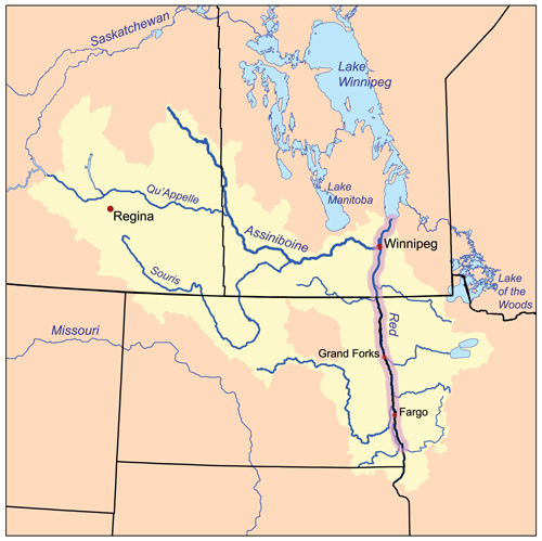
Súbor:Redrivernorthmap.png
Vzhľad
Redrivernorthmap.png (500 × 499 pixelov, veľkosť súboru: 137 KB, MIME typ: image/png)
História súboru
Po kliknutí na dátum/čas uvidíte ako súbor vyzeral vtedy.
| Dátum/Čas | Náhľad | Rozmery | Používateľ | Komentár | |
|---|---|---|---|---|---|
| aktuálna | 16:16, 15. február 2007 |  | 500 × 499 (137 KB) | Kmusser | This is a map of the Red River of the North drainage basin, with the Red River highlighted. I, Karl Musser, created it based on USGS and [[:en:Digital Chart of the World|Digital Chart of the |
Použitie súboru
Na tento súbor odkazuje nasledujúca stránka:
Globálne využitie súborov
Nasledovné ďalšie wiki používajú tento súbor:
- Použitie na bg.wikipedia.org
- Použitie na ca.wikipedia.org
- Použitie na ceb.wikipedia.org
- Použitie na cs.wikipedia.org
- Použitie na da.wikipedia.org
- Použitie na de.wikipedia.org
- Použitie na en.wikipedia.org
- Red River of the North
- Red River Floodway
- 1997 Red River flood
- List of rivers of Minnesota
- Red River Valley
- Talk:Winnipeg River
- User:Kmusser/Images
- Bois-Brûlés
- 1950 Red River flood
- 1997 Red River flood in the United States
- 2009 Red River flood
- Red River floods
- 1897 Red River flood
- 2011 Red River flood
- Pemmican War
- Métis buffalo hunting
- Battle of Grand Coteau
- Template:Red River of the North
- User:Zchan083/Métis buffalo hunt
- Použitie na en.wikinews.org
- Použitie na eo.wikipedia.org
- Použitie na es.wikipedia.org
- Použitie na et.wikipedia.org
- Použitie na fi.wikipedia.org
- Použitie na hu.wikipedia.org
- Použitie na it.wikipedia.org
- Použitie na ja.wikipedia.org
- Použitie na ko.wikipedia.org
- Použitie na nl.wikipedia.org
- Použitie na no.wikipedia.org
- Použitie na pl.wikipedia.org
- Použitie na pt.wikipedia.org
- Použitie na ro.wikipedia.org
- Použitie na ru.wikipedia.org
Zobraziť ďalšie globálne použitie tohto súboru.

